Home /
Expert Answers /
Earth Sciences /
need-help-plz-i-39-m-not-sure-my-ans-nbsp-use-the-base-reflectivity-image-to-describe-what-you-are-s-pa377
(Solved): need help plz, i'm not sure my ans Use the base reflectivity image to describe what you are se ...
need help plz, i'm not sure my ans
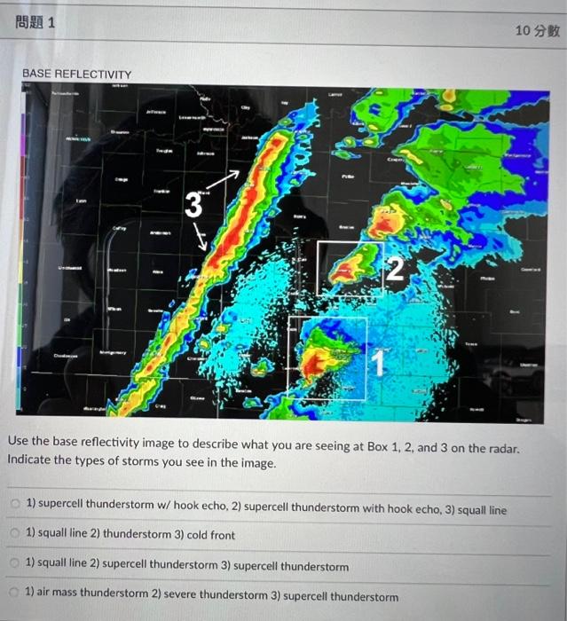
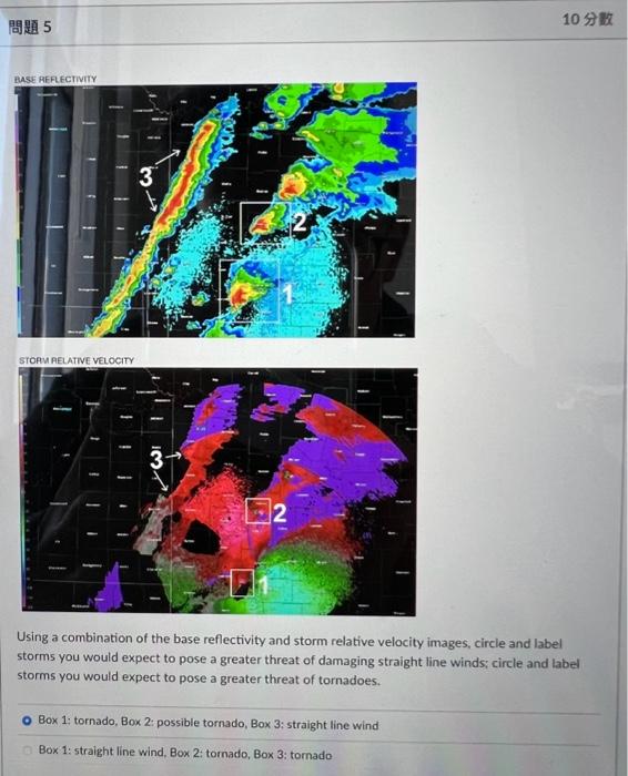

Use the base reflectivity image to describe what you are seeing at Box 1,2 , and 3 on the radar. Indicate the types of storms you see in the image. 1) supercell thunderstorm w/ hook echo, 2) supercell thunderstorm with hook echo, 3) squall line 1) squall line 2) thunderstorm 3) cold front 1) squall line 2) supercell thunderstorm 3) supercell thunderstorm 1) air mass thunderstorm 2) severe thunderstorm 3) supercell thunderstorm
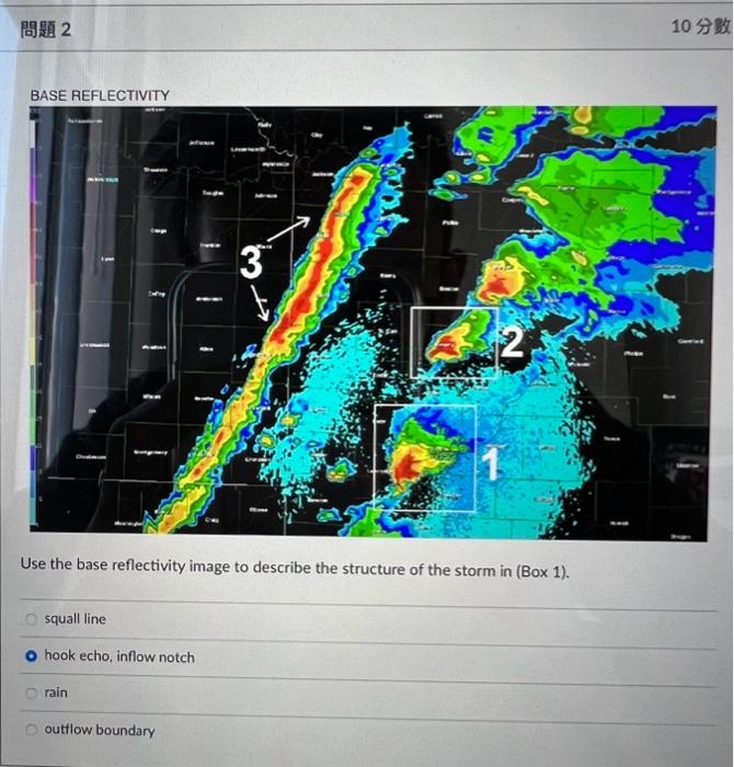
Use the base reflectivity image to describe the structure of the storm in (Box 1). squall line hook echo, inflow notch rain outflow boundary
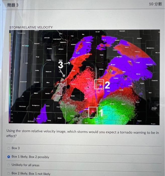
STORM RELATIVE VELOCITY Using the storm relative velocity image, which storms would you expect a tornado warning to be in effect? Box 3 Box 1 likely, Box 2 possibly Unlikely for all areas Box 2 likely, Box 1 not likely
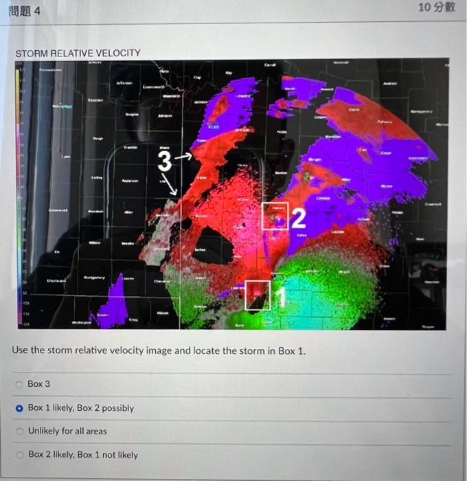
Use the storm relative velocity image and locate the storm in Box \( 1 . \) Box 3 Box 1 likely, Box 2 possibly Unlikely for all areas Box 2 likely, Box 1 not likely
STOAM AELATIVE VELOCITY Using a combination of the base reflectivity and storm relative velocity images, circle and label storms you would expect to pose a greater threat of damaging straight line winds; circle and label storms you would expect to pose a greater threat of tornadoes. Box 1: tornado, Box 2: possible tornado, Box 3: straight line wind Box 1: straight line wind, Box 2: tornado, Box 3: tornado
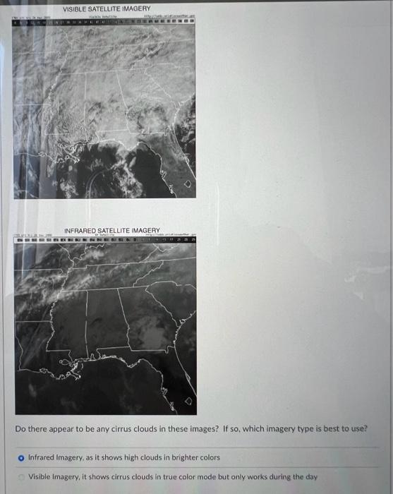
Do there appear to be any cirrus clouds in these images? If so, which imagery type is best to use? Infrared Imagery, as it shows high clouds in brighter colors Visible imagery, it shows cirrus clouds in true color mode but only works during the day
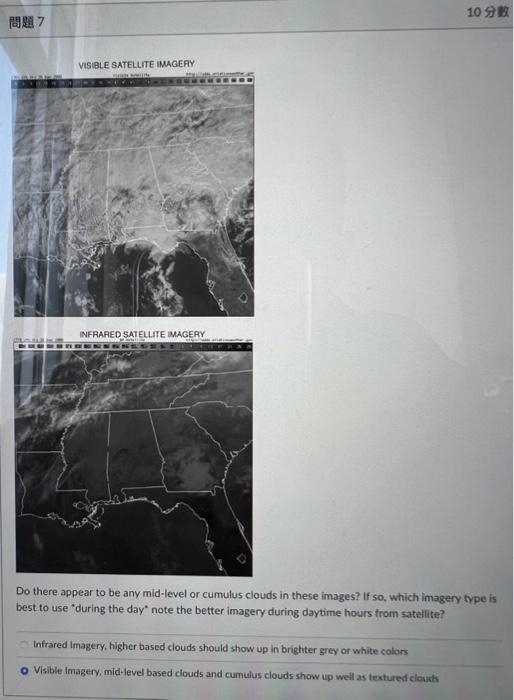
Do there appear to be any mid-level or cumulus clouds in these images? If so, which imagery type is best to use "during the day" note the better imagery during daytime hours from satellite? Infrared Imagery, higher based clouds should show up in brighter grey or white colors Visible Imagery, mid-level based clouds and cumulus clouds show up weil as textured clounk
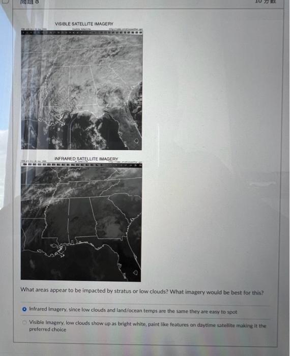
What areas appear to be impacted by stratus or low clouds? What imagery would be best for this? Infrared Imagery, since low clouds and land/ocean temps are the same they are easy to spot Visible imagery, low clouds show up as bright white, paint like features on daytime safellite making it the preferred choice
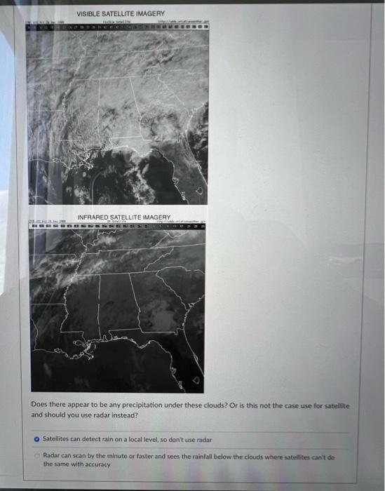
Does there appear to be any precipitation under these clouds? Or is this not the case use for satellite and should you use radar instead? Satellites can detect rain on a local level, so don't use radar Radar can scan by the minute or fasterand sees the raintall below the clouds where satelites cant do the same with aceuracy
Does there appear to be any precipitation under these clouds? Or is this not the case use for satelite and should you use radar instead? Sateilites can detect rain on a local level, so don't use radar Radar can scan by the minute or fasterand sees the raintall below the clouds where satelittes cant do the same with accuracy
Expert Answer
"Since you have asked multiple questions, we will solve the first one for you. If you want a specific question to be solved, please repost that spec